
Journal of Systems Engineering and Electronics ›› 2022, Vol. 33 ›› Issue (4): 938-950.doi: 10.23919/JSEE.2022.000091
• DEFENCE ELECTRONICS TECHNOLOGY • Previous Articles Next Articles
Tianjie LEI1,2( ), Jiabao WANG1,2,3(), Pingping HUANG4,5,*(), Weixian TAN4,5(), Yaolong QI4,5(), Wei XU4,5(), Chun ZHAO1()
Received:2021-03-29
Online:2022-08-30
Published:2022-08-30
Contact:
Pingping HUANG
E-mail:leitj@iwhr.com;Jiabao_wang@126.com;hpp@imut.edu.cn;wxtan@imut.edu.cn;qiyaolong@imut.edu.cn;xuwei1983@imut.edu.cn;zhaochun@iwhr.com
About author:Supported by:Tianjie LEI, Jiabao WANG, Pingping HUANG, Weixian TAN, Yaolong QI, Wei XU, Chun ZHAO. Time-varying baseline error correction method for ground-based micro-deformation monitoring radar[J]. Journal of Systems Engineering and Electronics, 2022, 33(4): 938-950.
Add to citation manager EndNote|Reference Manager|ProCite|BibTeX|RefWorks
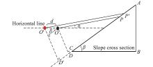
Fig 1
Schematic diagram of the impact of instrument instability on monitoring"

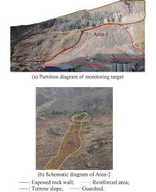
Fig 2
Schematic diagram of monitoring target"
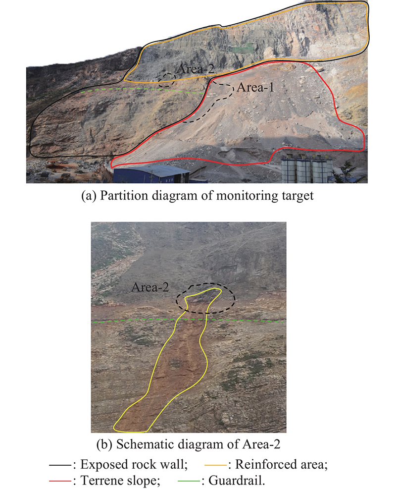
Table 1
Instrument parameters"
| Parameter | Value |
| Bandwidth/MHz | 500 |
| Field of view/(°) | >60 (azimuth) ×30 (elevation) |
| Repetition time/min | 8 |
| Resolution | 0.3 m × 5.4 mrad |
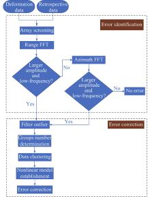
Fig 3
Flow chart of error identification and error correction"


Fig 4
Deformation data and review data"
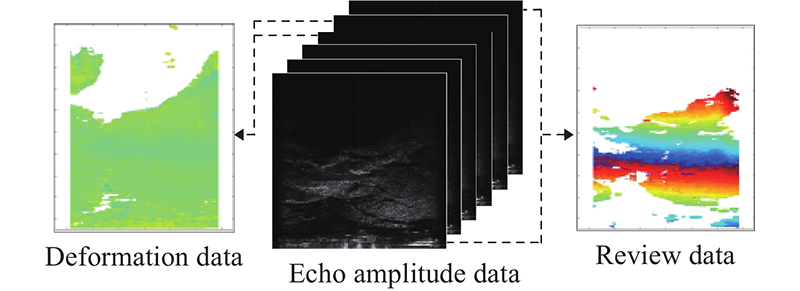
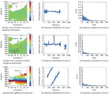
Fig 5
Characteristics of different types of data"
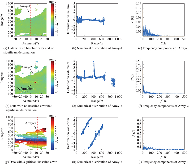
Table 2
Amplitude peak distribution of low-frequency components for different types of data % "
| Peak value | Type-1 | Type-2 | Type-3 |
| 0.0?0.3 | 88.3 | 23.2 | 0.0 |
| 0.3?0.6 | 11.7 | 76.8 | 0.0 |
| 0.6?1.0 | 0.0 | 0.0 | 47.2 |
| >1.0 | 0.0 | 0.0 | 52.8 |
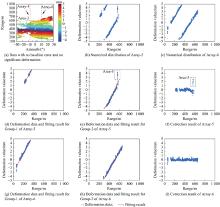
Fig 6
Example for error correction process"
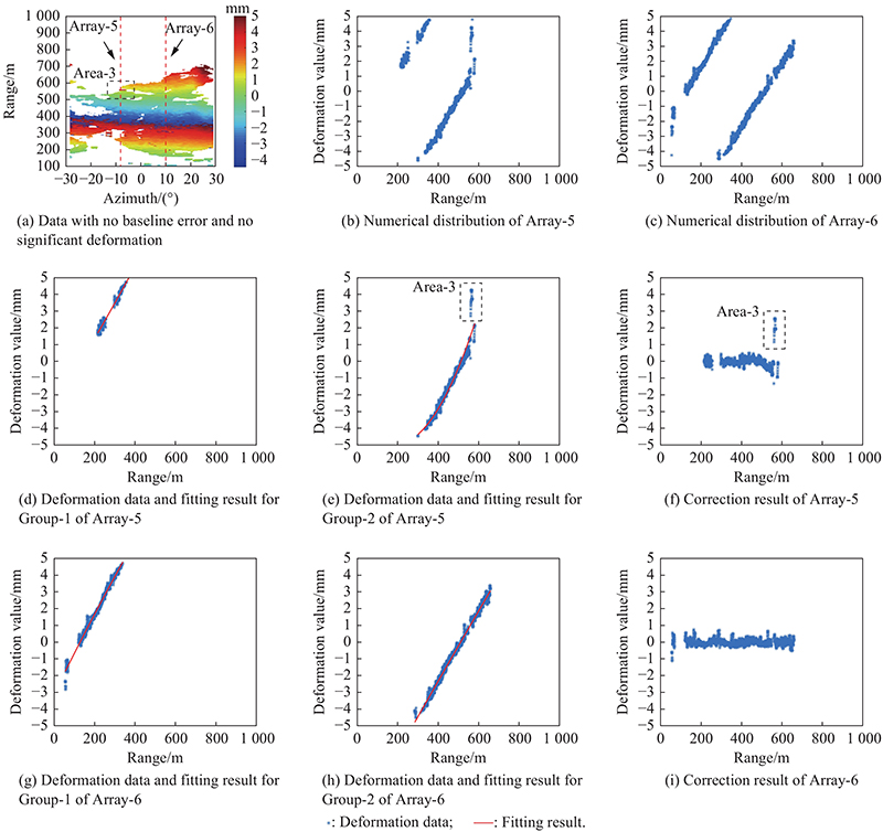
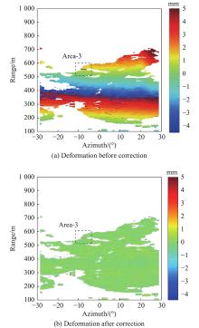
Fig 7
Deformation data comparison before and after correction"
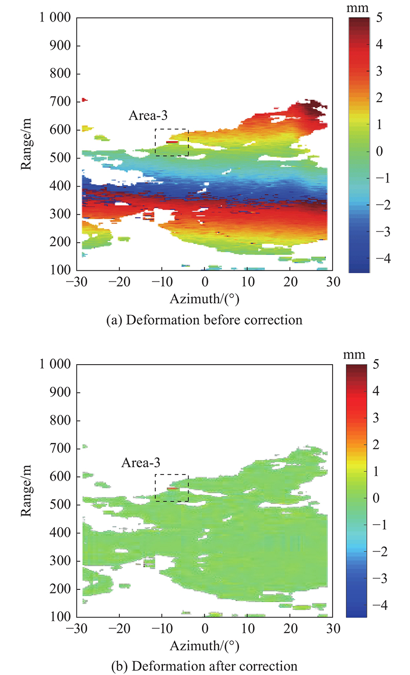
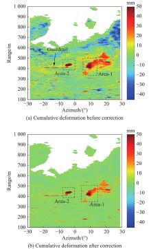
Fig 8
Cumulative deformation before and after correction within half a month"

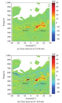
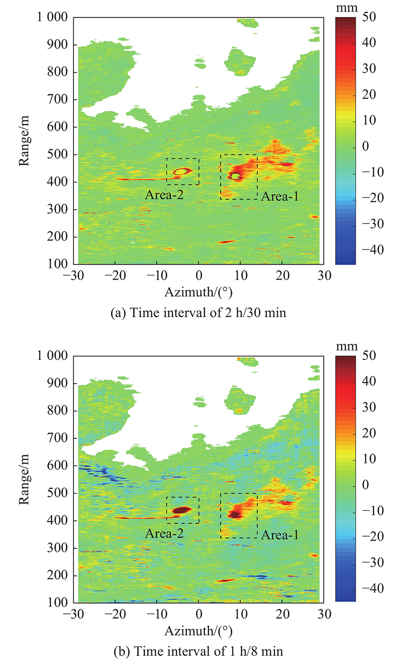
Fig 9
Correction cumulative deformation data comparison in different time interval"
| 1 |
BURGMANN R, ROSEN P A, FIELDING E J Synthetic aperture radar interferometry to measure Earth ’s surface topography and its deformation. Annual Review of Earth and Planetary Sciences, 2000, 28 (1): 169- 209.
doi: 10.1146/annurev.earth.28.1.169 |
| 2 |
XU J Q, SUN H P Earth’s deformation due to the dynamical perturbations of the fluid outer core. Acta Seismologica Sinica, 2002, 15 (4): 414- 424.
doi: 10.1007/s11589-002-0034-x |
| 3 |
FROUDE M J, PETLEY D N Global fatal landslide occurrence from 2004 to 2016. Natural Hazards and Earth System Sciences, 2018, 18 (8): 2161- 2181.
doi: 10.5194/nhess-18-2161-2018 |
| 4 |
ZHANG M, NIE L, XU Y, et al A thrust load-caused landslide triggered by excavation of the slope toe: a case study of the Chaancun landslide in Dalian city, China. Arabian Journal of Geosciences, 2015, 8 (9): 6555- 6565.
doi: 10.1007/s12517-014-1710-6 |
| 5 |
SAITO H, KORUP O, UCHIDA T, et al Rainfall conditions, typhoon frequency, and contemporary landslide erosion in Japan. Geology, 2014, 42 (11): 999- 1002.
doi: 10.1130/G35680.1 |
| 6 |
LIU J K, SHIH P T Topographic correction of wind-driven rainfall for landslide analysis in central Taiwan with validation from aerial and satellite optical images. Remote Sensing, 2013, 5 (6): 2571- 2589.
doi: 10.3390/rs5062571 |
| 7 |
VAN DER GEEST K Landslide loss and damage in Sindhupalchok District, Nepal: comparing income groups with implications for compensation and relief. International Journal of Disaster Risk Science, 2018, 9 (2): 157- 166.
doi: 10.1007/s13753-018-0178-5 |
| 8 |
PAUDEL P P, OMURA H, KUBOTA T, et al Landslide damage and disaster management system in Nepal. Disaster Prevention and Management, 2003, 12 (5): 413- 419.
doi: 10.1108/09653560310507235 |
| 9 |
BAJEK R, MATSUDA Y, OKADA N Japan ’s Jishu-bosai-soshiki community activities: analysis of its role in participatory community disaster risk management. Natural Hazards, 2008, 44 (2): 281- 292.
doi: 10.1007/s11069-007-9107-4 |
| 10 |
HUANG M, QI S Z, SHANG G D Karst landslides hazard during 1940–2002 in the mountainous region of Guizhou Province, Southwest China. Natural Hazards, 2012, 60 (2): 781- 784.
doi: 10.1007/s11069-011-0018-z |
| 11 | EDVIN A, DJAMIL Y S Application of multivariate Anfis for daily rainfall prediction: influences of training data size. Makara Journal of Science, 2008, 12 (1): 7- 14. |
| 12 |
ATZENI C, BARLA M, PIERACCINI M Early warning monitoring of natural and engineered slopes with ground-based synthetic-aperture radar. Rock Mechanics and Rock Engineering, 2015, 48 (1): 235- 246.
doi: 10.1007/s00603-014-0554-4 |
| 13 |
CARLA T, INTRIERI E, DI T F, et al Guidelines on the use of inverse velocity method as a tool for setting alarm thresholds and forecasting landslides and structure collapses. Landslides, 2017, 14 (2): 517- 534.
doi: 10.1007/s10346-016-0731-5 |
| 14 | XU Q, TANG M G, HUANG R Q. Monitoring, early warning and emergency disposal of large landslides. Beijing: Science Press, 2015. (in Chinese) |
| 15 |
BO H, CHEN J Y, ZHANG X F Monitoring the land subsidence area in a coastal urban area with InSAR and GNSS. Sensors, 2019, 19 (14): 3181.
doi: 10.3390/s19143181 |
| 16 |
WANG Y P, HONG W, ZHANG Y, et al Ground-based differential interferometry SAR: a review. IEEE Geoscience and Remote Sensing Magazine, 2020, 8 (1): 43- 70.
doi: 10.1109/MGRS.2019.2963169 |
| 17 |
PIERACCINI M, MICCINESI L, ROJHANI N A GBSAR operating in monostatic and bistatic modalities for retrieving the displacement vector. IEEE Geoscience and Remote Sensing Letters, 2017, 14 (9): 1494- 1498.
doi: 10.1109/LGRS.2017.2717857 |
| 18 | GE D Q, DAI K R, GUO Z C, et al Early identification of serious geological hazards with integrated remote sensing technologies: thoughts and recommendations. Geomatics and Information Science of Wuhan University, 2019, 44 (7): 949- 956. |
| 19 | HU F M, WU J C Detecting spatio-temporal urban surface changes using identified temporary coherent scatterers. Journal of Systems Engineering and Electronics, 2021, 32 (6): 1304- 1317. |
| 20 | FLORENTINO A, CHARAPAQUI S, JARA C, et al Implementation of a ground-based synthetic aperture radar (GB-SAR) for landslide monitoring: system description and preliminary results. Proc. of the IEEE XXIII International Congress on Electronics, Electrical Engineering and Computing, 2016, 1- 6. |
| 21 |
GRAHAM J D, ERIK E Development of an early-warning time-of-failure analysis methodology for open-pit mine slopes utilizing ground-based slope stability radar monitoring data. Canadian Geotechnical Journal, 2015, 52 (4): 515- 529.
doi: 10.1139/cgj-2014-0028 |
| 22 | ASLAN G, FOUMELIS M, RAUCOULES D Landslide mapping and monitoring using persistent scatterer interferometry (PSI) technique in the French Alps. Remote Sensing, 2020, 12 (8): 1305. |
| 23 |
TRAGLIA F, INTRIERI E, NOLESINI T, et al The ground-based InSAR monitoring system at Stromboli volcano: linking changes in displacement rate and intensity of persistent volcanic activity. Bulletin of Volcanology, 2014, 76 (2): 786.
doi: 10.1007/s00445-013-0786-2 |
| 24 |
SOGA K, ALONSO E, YERRO A, et al Trends in large-deformation analysis of landslide mass movements with particular emphasis on the material point method. Geotechnique, 2016, 66 (3): 248- 273.
doi: 10.1680/jgeot.15.LM.005 |
| 25 | ZENG T, DENG Y K, HU C, et al Development state and application examples of ground-based differential interferometric radar. Journal of Radars, 2019, 8 (1): 154- 170. |
| 26 | LI W L, XU Q Historical retrospection of deformation of large rocky landslides and its enlightenment. Geomatics and Information Science of Wuhan University, 2019, 44 (7): 1043- 1053. |
| 27 |
SIDLE R C, BOGAARD T A Dynamic earth system and ecological controls of rainfall-initiated landslides. Earth-science Reviews, 2016, 159, 275- 291.
doi: 10.1016/j.earscirev.2016.05.013 |
| 28 |
DAI K R, LI Z H, XU Q, et al Entering the era of earth observation-based landslide warning systems: a novel and exciting framework. IEEE Geoscience and Remote Sensing Magazine, 2020, 8 (1): 136- 153.
doi: 10.1109/MGRS.2019.2954395 |
| 29 |
GLASTONBURY J, FELL R Geotechnical characteristics of large slow, very slow, and extremely slow landslides. Canadian Geotechnical Journal, 2008, 45 (7): 984- 1005.
doi: 10.1139/T08-021 |
| 30 | QIN S Q, WANG Y Y, MA P Exponential laws of critical displacement evolution for landslides and avalanches. Chinese Journal of Rock Mechanics and Engineering, 2010, 29 (5): 873- 880. |
| 31 |
CROSETTO M, MONSERRAT O, LUZI G, et al Discontinuous GBSAR deformation monitoring. ISPRS Journal of Photogrammetry and Remote Sensing, 2014, 93, 136- 141.
doi: 10.1016/j.isprsjprs.2014.04.002 |
| 32 |
YIGIT E, DEMIRCI S, OZDEMIR C, et al Short-range ground-based synthetic aperture radar imaging: performance comparison between frequency-wavenumber migration and back-projection algorithms. Journal of Applied Remote Sensing, 2013, 7 (1): 073483.
doi: 10.1117/1.JRS.7.073483 |
| 33 |
MONSERRAT O, CROSETTO M, LUZI G A review of ground-based SAR interferometry for deformation measurement. ISPRS Journal of Photogrammetry and Remote Sensing, 2014, 93, 40- 48.
doi: 10.1016/j.isprsjprs.2014.04.001 |
| 34 | PAN X D, XU Y M, XING C, et al Study of a GB-SAR rail error correction method based on an incident angle model. IEEE Trans. on Geoscience and Remote Sensing, 2019, 58 (1): 510- 518. |
| 35 |
YANG H L, CAI J W, PENG J H A correcting method about GB-SAR rail displacement. International Journal of Remote Sensing, 2017, 38 (6): 1483- 1493.
doi: 10.1080/01431161.2017.1280631 |
| 36 |
HU C, ZHU M, ZENG T, et al High-precision deformation monitoring algorithm for GBSAR system: rail determination phase error compensation. Science China Information Sciences, 2016, 59 (8): 082307.
doi: 10.1007/s11432-015-5446-z |
| 37 | CROSETTO M, MONSERRAT O, LUZI G, et al A noninterferometric procedure for deformation measurement using GB-SAR imagery. IEEE Geoscience and Remote Sensing Letters, 2013, 11 (1): 34- 38. |
| 38 |
WANG Z, LI Z H, MILLS J Modelling of instrument repositioning errors in discontinuous multi-campaign ground-based SAR (MC-GBSAR) deformation monitoring. ISPRS Journal of Photogrammetry and Remote Sensing, 2019, 157, 26- 40.
doi: 10.1016/j.isprsjprs.2019.08.019 |
| 39 | OLIVER C, QUEGAN S. Understanding synthetic aperture radar images. Raleigh: SciTech Publishing, 2004. |
| 40 |
PIERACCINI M, MICCINESI L Ground-based radar interferometry: a bibliographic review. Remote Sensing, 2019, 11 (9): 1029.
doi: 10.3390/rs11091029 |
| 41 |
TOFANI V, RASPINI F, CATANI F, et al Persistent scatterer interferometry (PSI) technique for landslide characterization and monitoring. Remote Sensing, 2013, 5 (3): 1045- 1065.
doi: 10.3390/rs5031045 |
| 42 | ZHANG H. Research on DInSAR method based on coherent target. Beijing: Science Press, 2009. (in Chinese) |
| 43 | WANG J F, PENG J H, YANG H L, et al InSAR phase unwrapping algorithm based on improved integral method. Science of Surveying and Mapping, 2016, 41 (12): 85- 88. |
| 44 | LIU G X, CHEN Q, LUO X J, et al. Radar interference theory and method based on permanent scatterer. Beijing: Science Press, 2012. (in Chinese) |
| 45 |
ZEBKER H A, LU Y Phase unwrapping algorithms for radar interferometry: residue-cut, least-squares, and synthesis algorithms. Journal of the Optical Society of America A, 1998, 15 (3): 586- 598.
doi: 10.1364/JOSAA.15.000586 |
| 46 |
ZHA X J, SHAO Z G, DAI Z Y, et al Accurate frequency estimation for removal of orbital fringes in SAR interferograms. International Journal of Remote Sensing, 2020, 41 (14): 5305- 5320.
doi: 10.1080/01431161.2020.1731772 |
| 47 | TIAN X, LIAO M S The analysis of conditions for InSAR in the fifield of deformation monitoring. Chinese Journal of Geophysics, 2013, 56 (3): 812- 823. |
| 48 | GUO L P, YUE J P Analysis coherence effected by baseline and time interval. Bulletin of Surveying and Mapping, 2018, 7, 9- 12. |
| 49 |
TOUZI R, LOPES A Coherence estimation for SAR imagery. IEEE Trans. on Geoscience and Remote Sensing, 1999, 37 (1): 135- 149.
doi: 10.1109/36.739146 |
| 50 |
ZEBKER H A, VILLASENOR J Decorrelation in interferometric radar echoes. IEEE Trans. on Geoscience and Remote Sensing, 1992, 30 (5): 950- 959.
doi: 10.1109/36.175330 |
| 51 | BIGGS J, WRIGHT T, LU Z, et al Multi-interferogram method for measuring interseismic deformation: Denali fault, Alaska. Geophysical Journal of the Royal Astronomical Society, 2010, 170 (3): 1165- 1179. |
| 52 | LI Q Y, WANG N C. Numerical analysis. Beijing: Tsinghua University Press, 2008. |
| 53 | XU Q, DONG X J, LI W L Integrated space-air-ground early detection, monitoring and warning system for potential catastrophic geohazards. Geomatics and Information Science of Wuhan University, 2019, 44 (7): 957- 966. |
| 54 |
HUANG Z S, SUN J P, LI Q, et al Time and space varying atmospheric phase correction in discontinuous ground-based synthetic aperture radar deformation monitoring. Sensors, 2018, 18 (11): 3883.
doi: 10.3390/s18113883 |
| [1] | Zhu Zhengwei, & Zhou Jianjiang. Optimum selection of common master image for ground deformation monitoring based on PS-DInSAR technique [J]. Journal of Systems Engineering and Electronics, 2009, 20(6): 1213-1220. |
| Viewed | ||||||
|
Full text |
|
|||||
|
Abstract |
|
|||||