Journal of Systems Engineering and Electronics ›› 2023, Vol. 34 ›› Issue (4): 1042-1052.doi: 10.23919/JSEE.2023.000090
• • 上一篇
-
收稿日期:2021-09-30出版日期:2023-08-18发布日期:2023-08-28
Research on FMC analytic algorithm of PBN track transition coding
Guangming ZHANG( ), Siqian REN(), Weiwei ZHAO(), Xiuyi LI()
- 1 School of Flight Technology, Civil Aviation Flight University of China, Guanghan 618307, China
-
Received:2021-09-30Online:2023-08-18Published:2023-08-28 -
Contact:Guangming ZHANG E-mail:gmzhang@cafuc.edu.cn;rensiqian202107@126.com;zww@cafuc.edu.cn;lixiuyi6690@163.com -
About author:
ZHANG Guangming was born in 1971. He received his master’s degree from University of Electronic Science and Technology of China in 2001. He is a professor in Civil Aviation Flight University of China. His current research interests are modern navigation technology and performance based navigation, navigation database and flight management computer. E-mail: gmzhang@cafuc.edu.cn
REN Siqian was born in 1995. She received her bachelor’s degree from Chengdu Neusoft University in 2019. She is a postgraduate student in Civil Aviation Flight University of China. Her current research interests are performance based navigation, navigation database and flight management computer. E-mail: rensiqian202107@126.com
ZHAO Weiwei was born in 1982. She received her master’s degree from Civil Aviation Flight University China in 2019. She is a lecturer in Civil Aviation Flight University of China. Her current research interests are performance based navigation and navigation database and flight simulation. E-mail: zww@cafuc.edu.cn
LI Xiuyi was born in 1972. He received his master’s degree from Southwest University of China in 2007. He is a senior pilot, professor, National Meritorious Pilot, and outstanding contribution expert of Sichuan. His current research interest is civil aviation flight technology and security. E-mail: lixiuyi6690@163.com -
Supported by:This work was supported by the National Natural Science Foundation of China (u2133209)
引用本文
. [J]. Journal of Systems Engineering and Electronics, 2023, 34(4): 1042-1052.
Guangming ZHANG, Siqian REN, Weiwei ZHAO, Xiuyi LI. Research on FMC analytic algorithm of PBN track transition coding[J]. Journal of Systems Engineering and Electronics, 2023, 34(4): 1042-1052.
"
| Path type | Path termination way |
| I = Initial | A = Altitude |
| T = Track to | C = Distance |
| C = Course to | D = DME distance |
| D = Direct to | F = Fix |
| F = Fix to | I = Intercept |
| H = Holding | M = Manual |
| P = Procedure turn | R = Radial |
| A = Arc | A = Altitude |
| R = Constant radius arc | C = Distance |
| V = Heading to | D = DME distance |
"
| Type | Termination method | Typical leg | Characteristics |
| Point | Point termination | IF | IF represents the initial point of the procedure |
"
| Type | Termination method | Typical leg | Characteristics |
| Arc | Point termination | CF | CF represents a non-stop flight along the rhumb line to the waypoint ahead with the course and the waypoint ahead given by the NavDB |
| DF | For DF, the track is determined according to the turning direction, the position of the waypoint ahead and the aircraft model data in the NavDB | ||
| RF | For RF, the track is determined according to the three-dimensional positions of the starting fix and the termination fix and the aircraft model data in the NavDB |
"
| Type | Termination method | Typical leg | Characteristics |
| Arc | Intercept termination | VI | VI has no definite termination point and interception of the next leg is realized in a certain heading |
"
| Type | Termination method | Typical leg | Characteristics |
| Segment | Point termination | TF/CF/DF | The termination point location is given by the NavDB |
| Altitude termination | CA/FA/VA | The altitude of the termination point is determined but the location is not |
"
| Type | Termination method | Typical leg | Characteristics |
| Holding | Point termination | HF | HF indicates the holding procedure that terminates at the holding fix |
| Altitude termination | HA | HA indicates the holding procedure that terminates upon climbing to a certain altitude | |
| Manual termination | HM | HM indicates the holding procedure that terminates manually without a fixed termination position |
"
"
| Parameter | Parameter meaning | Value |
| | Current true air speed of aircraft | − |
| | Current ground speed of aircraft | − |
| | Turn lead distance | |
| | Track variation | When barometric altitude When barometric altitude |
| | Aircraft bank angle | 5° |
"
"
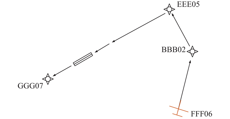
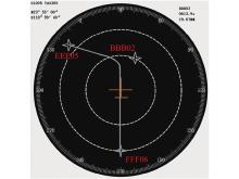
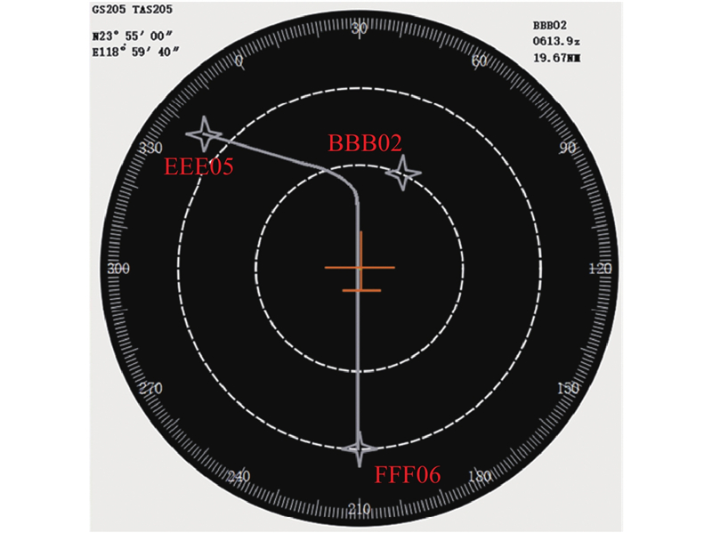
| Waypoint | Geodetic coordinates |
| BBB02 | N24°49'55.20", E119°0'21.60" |
| EEE05 | N25°12'3.60", E119°18'43.20" |
| FFF06 | N23°46'33.6", E118°59'31.20" |
"
| Waypoint | PT | MH/(°) | Altitude/m | Speed/kt |
| FFF06 | IF | 30 | − | − |
| BBB02 | TF | − | − | − |
| EEE05 | TF | − | 1000 | 205 |
"
"
"
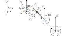
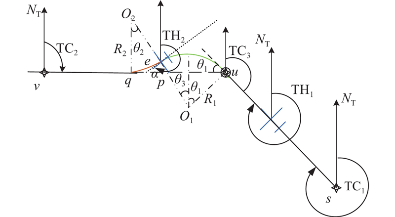
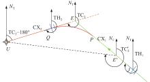
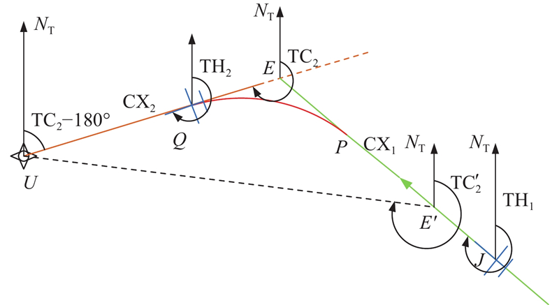
| Parameter | Parameter meaning | Value |
| | Coordinates of waypoint | − |
| | Coordinates of waypoint | − |
| | Current true heading of aircraft | − |
| | True course of next leg | − |
| | After the aircraft flies over the waypoint, it intercepts the true heading of the next leg | − |
| | After the aircraft flies over the waypoint, it intercepts the intercept angle of the next leg | 30° |
"
"
| S/N | Target altitude/m | Horizontal coordinates of target point |
| 1 | 850 | E112°24′13.10″, N30°46′52.95″ |
| 2 | 1250 | E112°21′46.00″, N30°54′20.25″ |
| 3 | 1650 | E112°19′27.21″, N31°01′21.12″ |
| 4 | 2050 | E112°17′12.63″, N31°08′08.22″ |
| 5 | 2450 | E112°15′0.40″, N31°14′47.24″ |
"
"
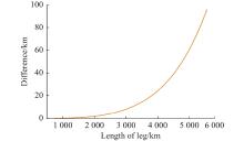
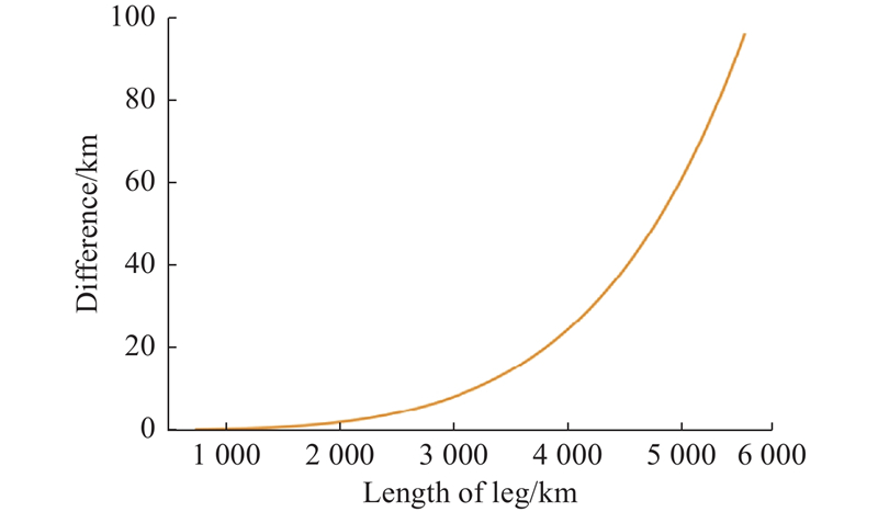
| Coordinates of point | Great circle distance/km | Rhumb line distance/km | Difference/m |
| N35°40′50″ E105°20′00″ | 724.297 | 724.365 | 68.55 |
| N40°40′50″ E110°20′00″ | 1429.881 | 1430.500 | 618.95 |
| N45°40′50″ E115°20′00″ | 2113.637 | 2115.974 | 2337.16 |
| N50°40′50″ E120°20′00″ | 2772.188 | 2778.314 | 6126.10 |
| N55°40′50″ E125°20′00″ | 3401.874 | 3414.968 | 13094.00 |
| N60°40′50″ E130°20′00″ | 3998.746 | 4023.244 | 24497.88 |
| N65°40′50″ E135°20′00″ | 4558.586 | 4600.203 | 41616.30 |
| N70°40′50″ E145°20′00″ | 5076.948 | 5142.424 | 65476.28 |
| N75°40′50″ E150°20′00″ | 5549.241 | 5645.473 | 96231.52 |
"
"
"
"
"
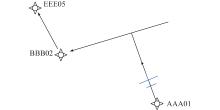
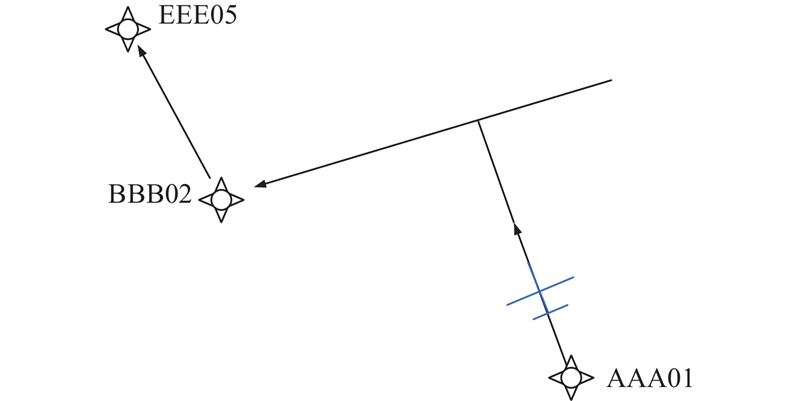
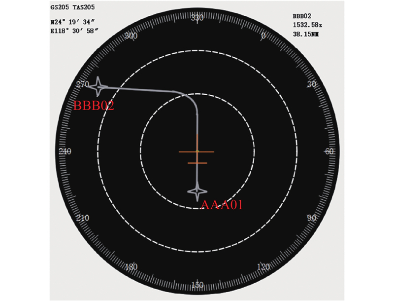
| Waypoint | Geodetic coordinates |
| AAA02 | N24°11′9.6″, E118°25′58.8″ |
| BBB02 | N24°49′55.20″, E119°0′21.60″ |
| EEE05 | N25°12′3.60″, E119°18′43.20″ |
"
| Waypoint | PT | MH/(°) | Altitude/m | Speed/kt |
| AAA01 | VI | 331 | − | − |
| BBB02 | CF | − | − | − |
"
"

"
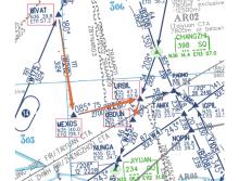
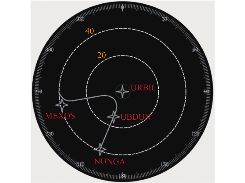
| Waypoint | Geodetic coordinates |
| BIVAT | N36°39.8′00″, E111°57.2′00″ |
| MEXOS | N35°40′00″, E112°04′01″ |
| URBIL | N35°40′00″, E112°52.9′00″ |
| UBDUN | N35°36.7′00″, E113°23.9′00″ |
"
| Leg | Chart distance/NM |
| BIVAT→MEXOS | 60 |
| MEXOS→URBIL | 40 |
| URBIL→UBDUN | 13 |
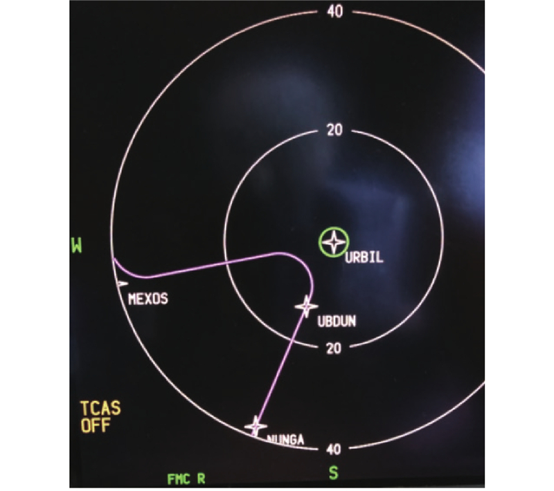
"
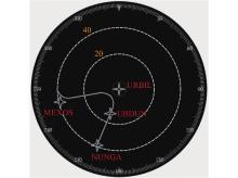
| Leg | Simulation distance/NM |
| BIVAT→MEXOS | 59.970 |
| MEXOS→URBIL | 40.354 |
| URBIL→UBDUN | 12.998 |
"

"
"
| Waypoint ahead | Distance/NM |
| MEXOS | 5.27 |
| URBIL | 6.016 |
"
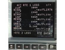
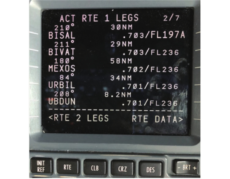
| Leg | FMC-predicted distance/NM |
| MEXOS→URBIL | 34.338 |
| URBIL→UBDUN | 8.204 |
"

"
"
| Speed/kt | FMC-predicted distance/NM | Difference between FMC-predicted distance and chart distance/NM |
| 190 | 50.25 | 2.65 |
| 210 | 49.56 | 3.31 |
| 230 | 48.81 | 4.03 |
| 250 | 48.17 | 4.83 |
| 270 | 47.11 | 5.68 |
| 290 | 45.68 | 6.59 |
| 310 | 44.67 | 7.55 |
| 330 | 43.71 | 8.51 |
| 350 | 43.26 | 9.30 |
| 370 | 44.23 | 9.01 |
| 390 | 45.84 | 7.56 |
| 1 | International Civil Aviation Organization. The civil aviation industry development statistical bulletin in 2018. Beijing: Civil Aviation Administration of China, 2018. |
| 2 | The Boeing Company. Patent issued for communication of flight management computer data via a wireless interface of a data capture device. USA: US10032382B2, 2018. |
| 3 | AC-91-FS-2014-21. Air operator navigation database management. Beijing: Civil Aviation Administration of China, 2014. |
| 4 | SONG K ARINC 424 coding analysis and track generating of terminal procedures. Air Traffic Management, 2010, (8): 50- 53. |
| 5 | PANG Y, ZHANG W G, LI G W, et al Construction algorithm of horizontal guiding transition path for flight management system. Journal of Civil Aviation University of China, 2014, 32 (3): 6- 10. |
| 6 | DING Y H. Flight program design aid based on navigation database. Tianjin: Civil Aviation University of China, 2015. (in Chinese) |
| 7 | YANG S Approach on simplified method of navigation database coding for Pudong airport. Journal of Civil Aviation, 2018, 2 (6): 60- 62. |
| 8 | DE NOVELLIS V, REALE D, ADINOLFI G M, et al Geodetic model of the March 2021 Thessaly seismic sequence inferred from seismological and InSAR data. Remote Sensing, 2021, 13 (17): 78- 80. |
| 9 | KUCHERENKO P A, SOKOLOV S V Analytical solution for a problem on approximation of functional dependences for parameters of a geodesic line. Mechanics of Solids, 2019, 54 (1): 40- 47. |
| 10 | Deere & Company. Patent issued for navigation system and method using RTK with data received from a mobile base station. USA : USPTO 9846241-B2, 2018. |
| 11 | Doc 8168. Aircraft operations, Volume I − flight procedures , sixth edition. Montreal, Canada: International Civil Aviation Organization, 2018. |
| 12 | 702A-5. Flight management computer system. USA: Aeronautical Radio, 2018. |
| 13 | Doc 9906-AN472. Flight program design quality assurance manual. Montreal: International Civil Aviation Organization, 2009. |
| 14 |
MAXIM K, LUIS R Flight management system for hydrogen-powered aircraft in cruise. Aerospace Systems, 2021, 4, 201- 208.
doi: 10.1007/s42401-021-00097-8 |
| 15 | GUO H, QI J T, LIU H L, et al Modeling method of double angle quantitative adjustment mechanism based on coordinate transformation. Experimental Technology And Management, 2021, 38 (6): 107- 111. |
| 16 | YANG Y C, SUN R M Research on the solving method of nonlinear equations based on Python. Electronic Measurement Technique, 2020, 43 (14): 55- 59. |
| 17 |
YU Z, WANG Y Y Geodesy ecological perspective of architectural tectonics in green building design. Arabian Journal of Geosciences, 2021, 14 (17): 1685.
doi: 10.1007/s12517-021-08142-8 |
| 18 | CHEN H, WU D, LI H P, et al The formula and improvement for calculating the track of equiangular route. Marine Surveying and Mapping, 2018, 38 (1): 67- 70. |
| 19 | YAN F X, NIU Z J, DU S W, et al Development and practice of C/C++ for android application based on Qt. Computer Systems and Applications, 2018, 27 (7): 96- 102. |
| 20 | WANG X H, NIE X H, CHANG L, et al Design and development of GUI module for special finite element software based on Qt. Computer Applications and Software, 2020, 37 (1): 21- 26,65. |
| 21 | ERDOR T B, SARUL M H, CENGELCI E, et al Integrated process control-power management system design and flight performance tests for fuel cell powered mini-unmanned aerial vehicle. Energy Technology, 2021, 9 (3): 2000879. |
| 22 | NGUYEN D D, ROHACS J, ROHACS D et al. Autonomous flight trajectory control system for drones in smart city traffic management. ISPRS International Journal of Geo-Information, 2021, 10 (5): 338. |
| 23 |
HIRAGUCHI H Novel study on the electron density distribution projection maps calculated via the discrete cosine transform. Journal of Applied Crystallography, 2021, 54, 1198- 1206.
doi: 10.1107/S1600576721006580 |
| 24 | LIU W C, BIAN H W Polar grid isometric route based on polar spherical projection. Journal of Aeronautics, 2019, 48 (1): 18- 23. |
| 25 |
ZHONG H N, MAO T Y A comprehensive thalamocortical projection map at the mesoscopic level. Nature Neuroscience, 2021, 24 (5): 754.
doi: 10.1038/s41593-021-00838-0 |
| 26 | CHRISTEN O M, MOSCHING Y, MULLER P, et al Dashboard visualization of information for emergency medical services. Studies in Health Technology and Informatics, 2020, 275, 27- 31. |
| 27 | The Boeing Company. B787-800 flight crew operation manual. USA: D6-27370-86N-HNA, 2011. |
| No related articles found! |
| 阅读次数 | ||||||
|
全文 |
|
|||||
|
摘要 |
|
|||||